Fly VFR with a chart that's always under you.
PilotCharts overlays your live GPS position on real aeronautical charts from openAIP — cached to your device automatically, so it keeps working with no signal. Explore over 50,000 airfields with official AIP chart links, see active and deactivated airspace NOTAMs directly on your moving chart with TFR boundaries, track your planes fleet and live Air Traffic with real photos, plan routes with 2D terrain elevation cross-sections, and fly with a Glass PFD or analog steam gauges.
Free for moving map and airport info. All premium features free with account creation during beta.

Public beta on Apple TestFlight • Open beta on Google Play
Your aviation map. Your way.
Take a 40-second tour through the live VFR moving map, dynamic airspace NOTAM status, route vertical profiles, and cockpit instruments.
Full feature tour
Three minutes, recorded from the real app: layers, airspaces, airports, forecast, routes, cockpit, traffic, Library, Notepad and offline use.
Everything you need to find your way
The core moving map is free for every pilot — no trial, no account, no catch.
Live moving map
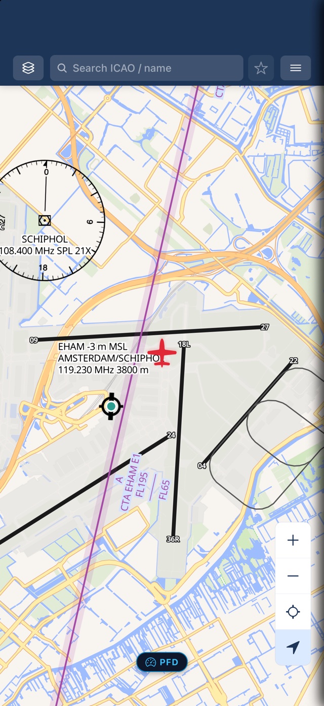
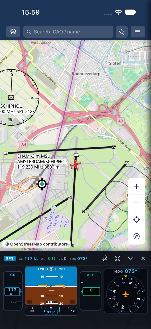
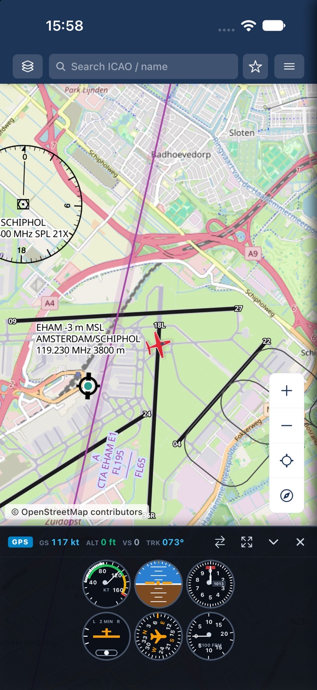
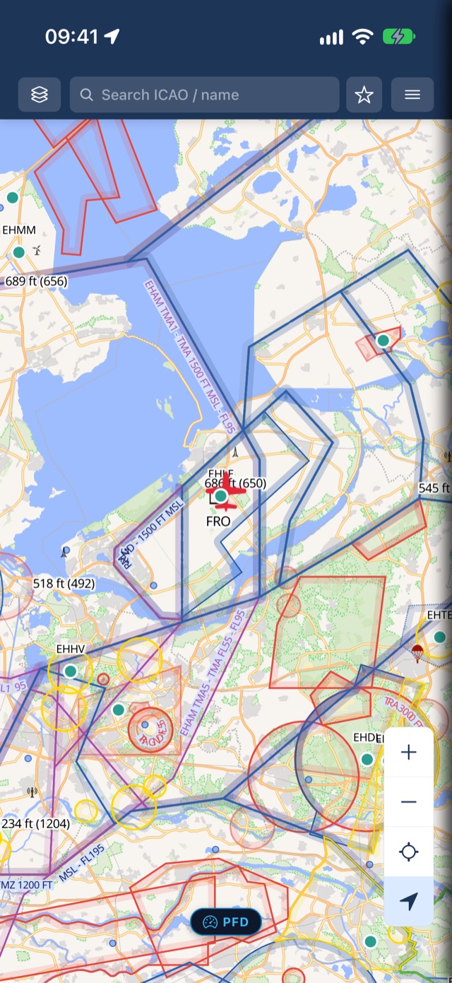
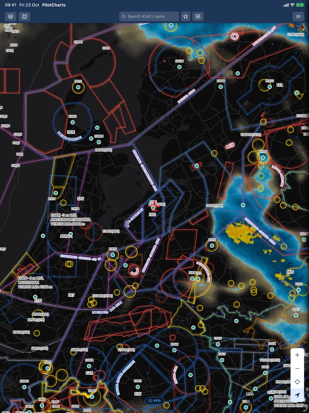
Your position, rendered as a rotating aircraft on top of a real VFR aeronautical chart — OpenStreetMap base plus openAIP's chart overlay.
Works with no signal
Map tiles cache to disk automatically as you fly. Pan over an area once online, and it keeps working offline — no manual downloads for the map itself.
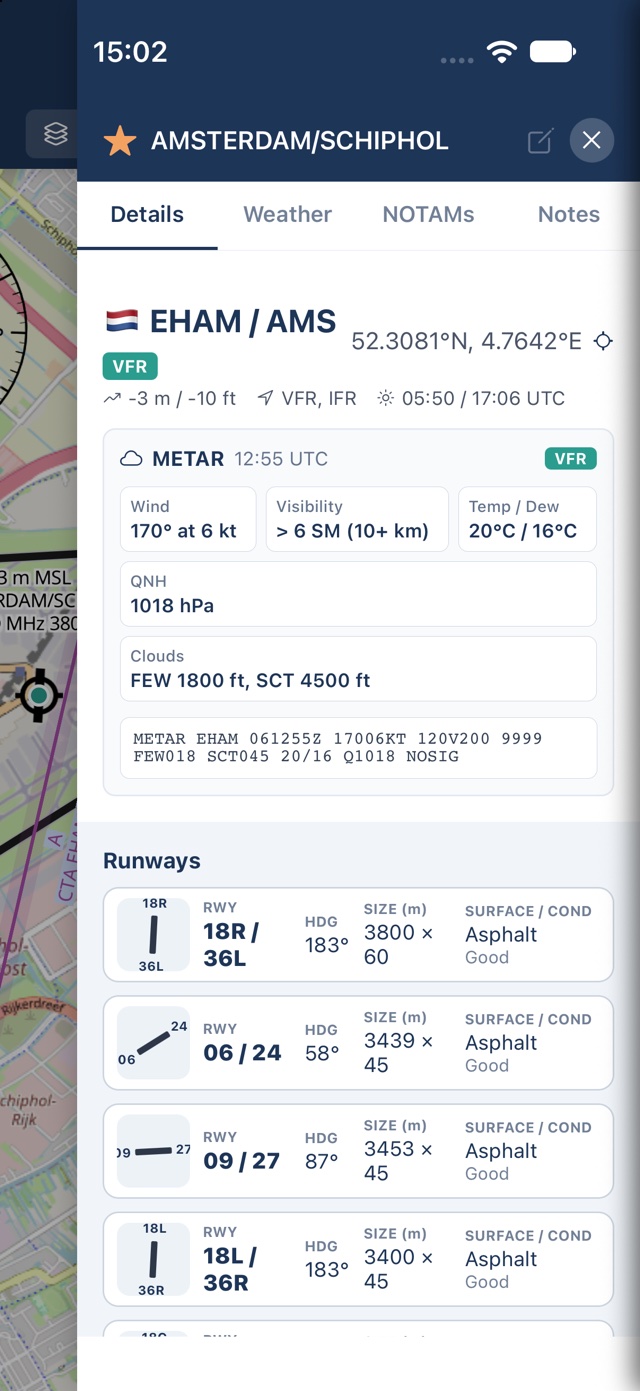
Airport details from openAIP
Elevation, runways, frequencies, PPR, contact info, and hours of operation — straight from openAIP, for airports worldwide.
50,000+ airfields & grass strips
Search international airports, regional hubs, unpaved backcountry grass strips, glider fields, and ultralight sites with national flag badges and code tags.
Official charts, one tap away
Jump straight to an aerodrome's official chart PDF from the national AIP, opened in your browser — never redistributed in-app.
Instant search & filter
Find any aerodrome by ICAO code, IATA code, or name with live search-as-you-type, plus live search across all app and map display settings.
Flight stopwatch
Floating cockpit stopwatch with pause/resume and lap reset for hold entries, procedure turns, and leg timing — with customizable corner placement.
Deep map personalization
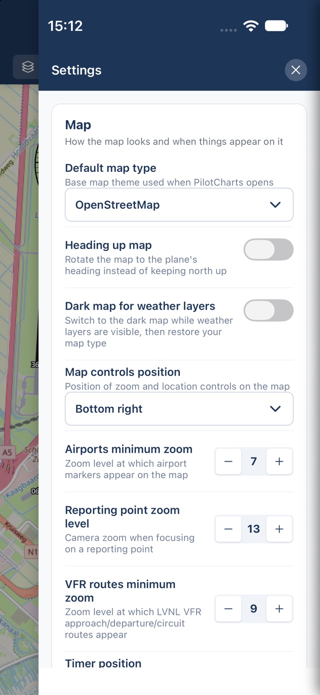
Choose North-Up or Heading-Up orientation, configure custom follow zoom levels, select multiple base map themes, position floating controls in any corner, and fly with full multilingual localization in 9 languages.
Download what you need
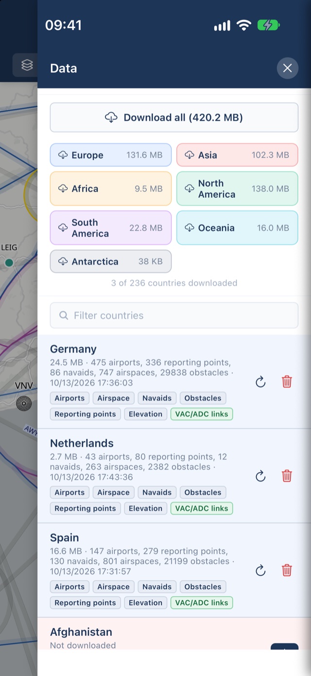
Pull airports, reporting points, navaids, airspace and obstacles for any country, worldwide — free, by country, forever.
See it in the cockpit
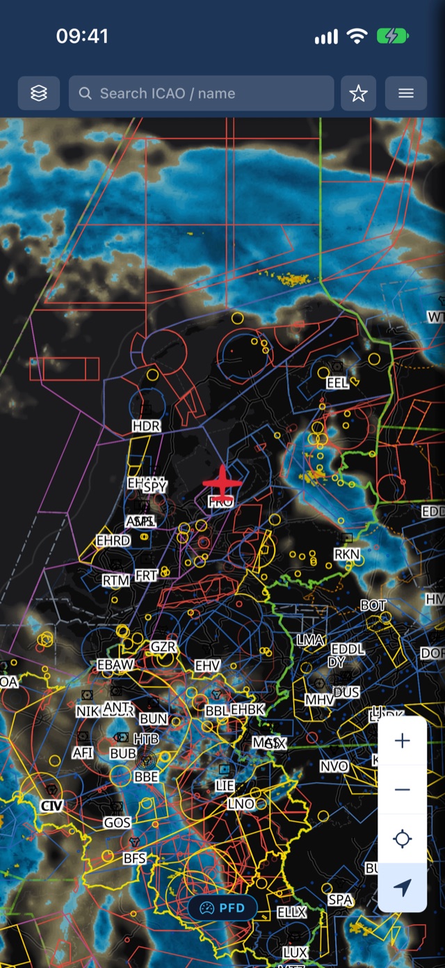
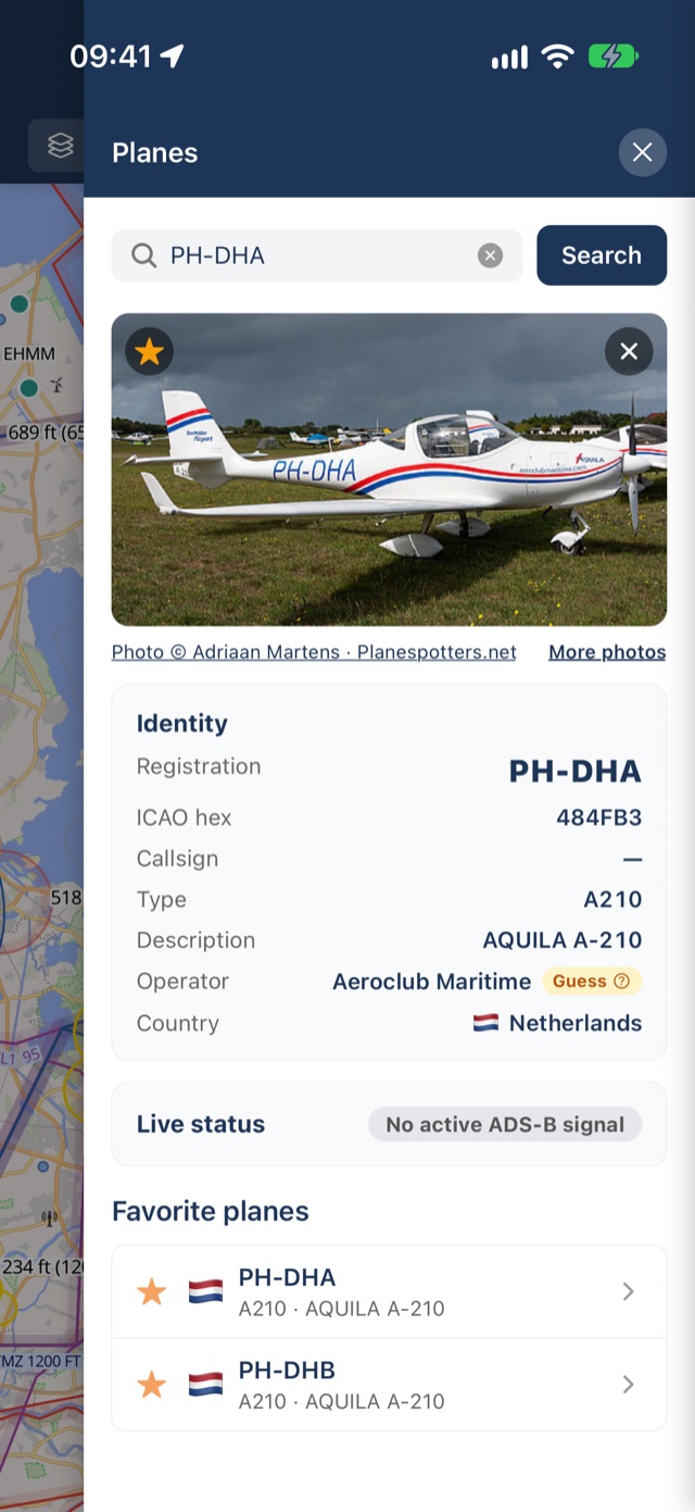
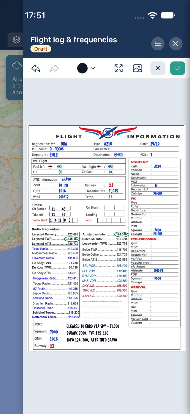
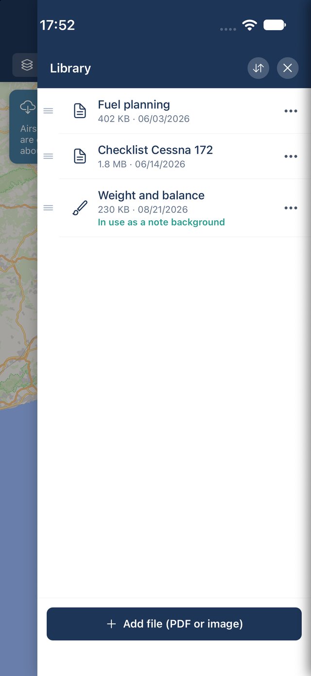
Real screens from PilotCharts on iPhone and iPad. Tap any screenshot to zoom in.
iPhone
iPad
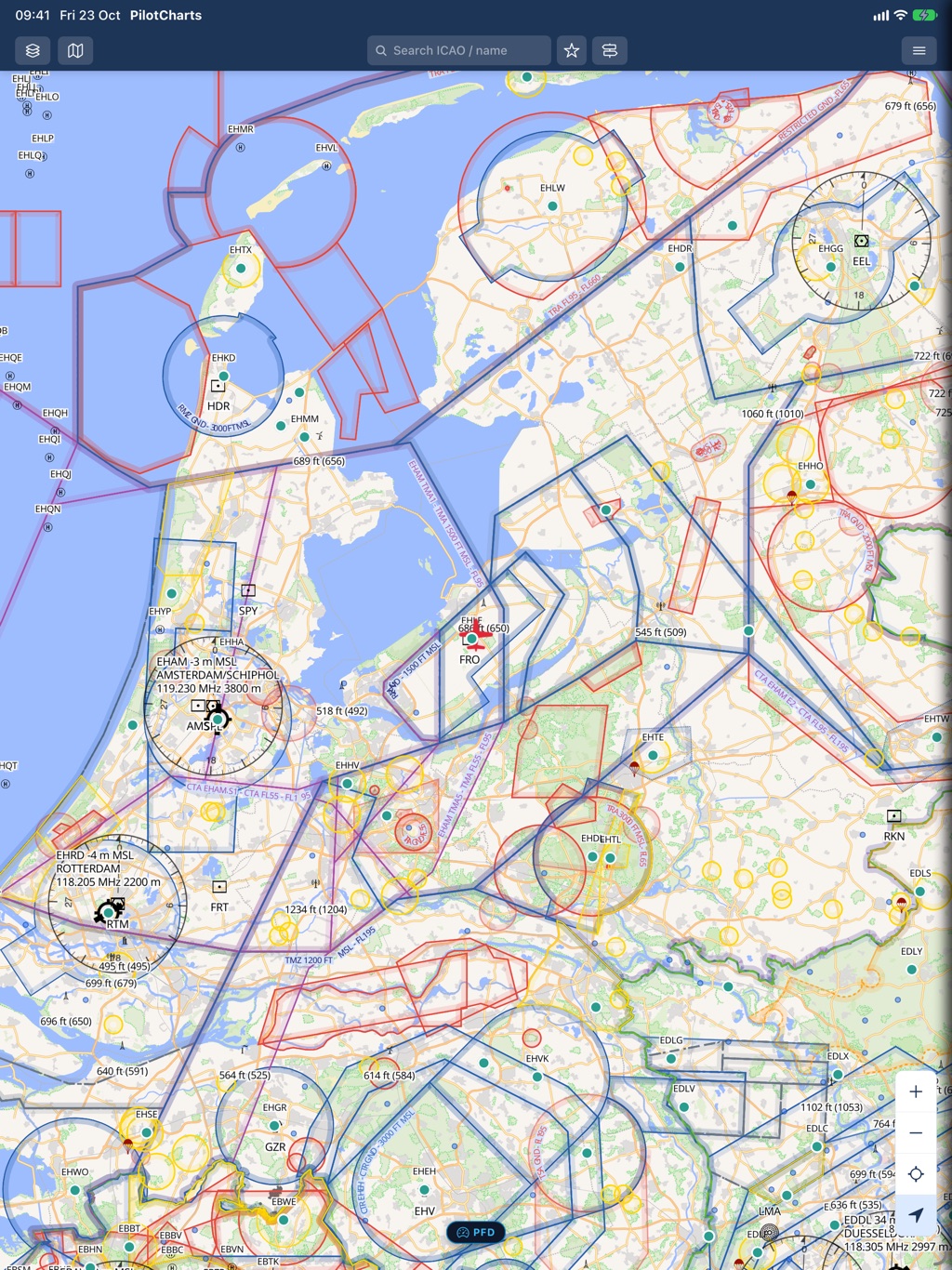
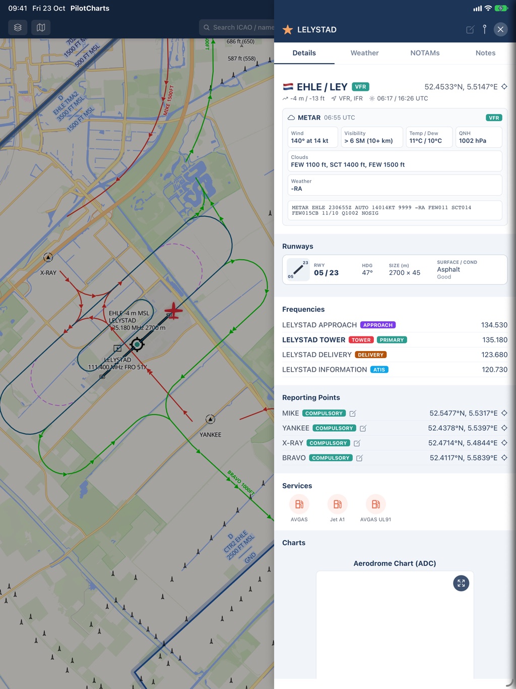
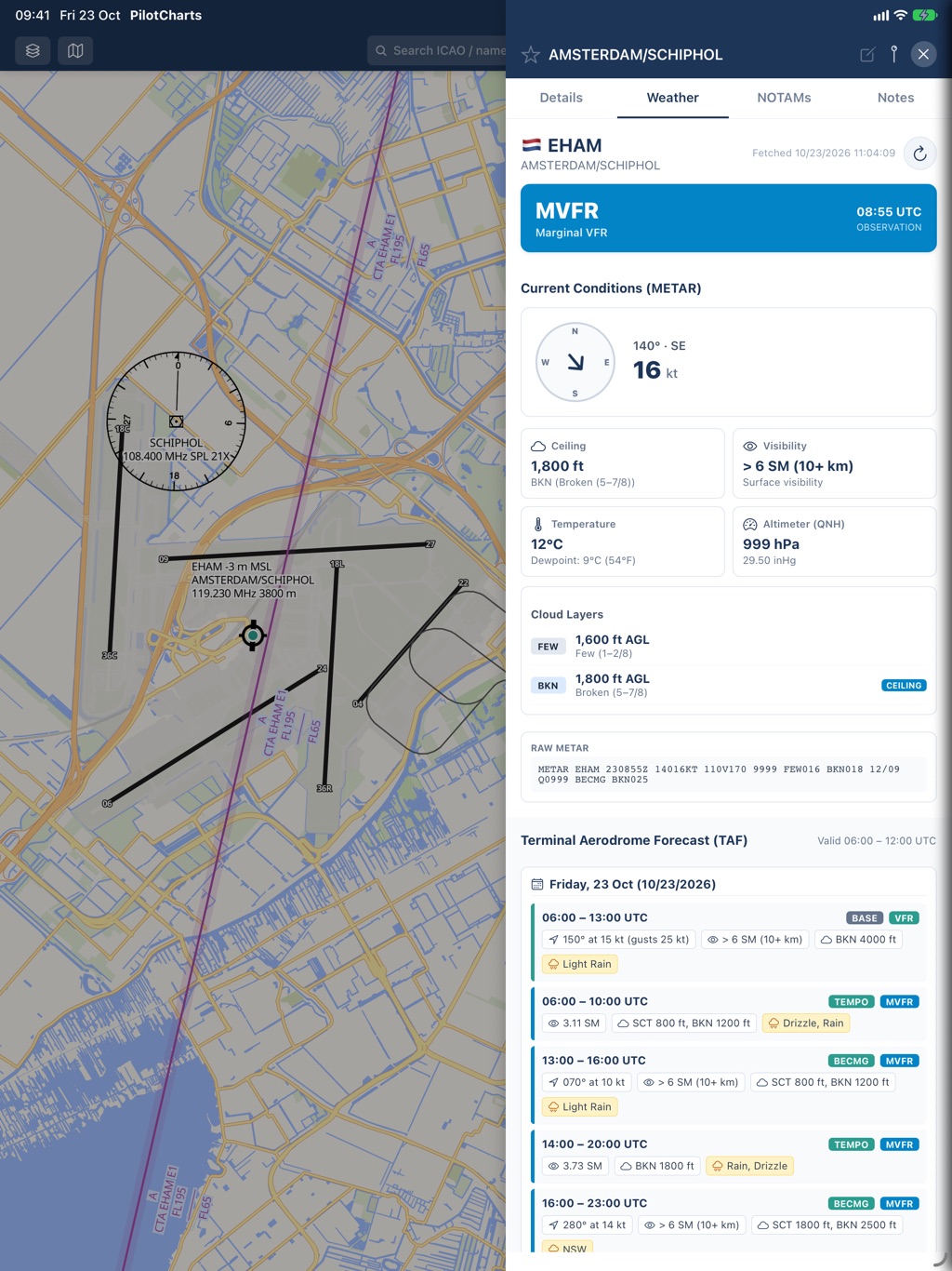
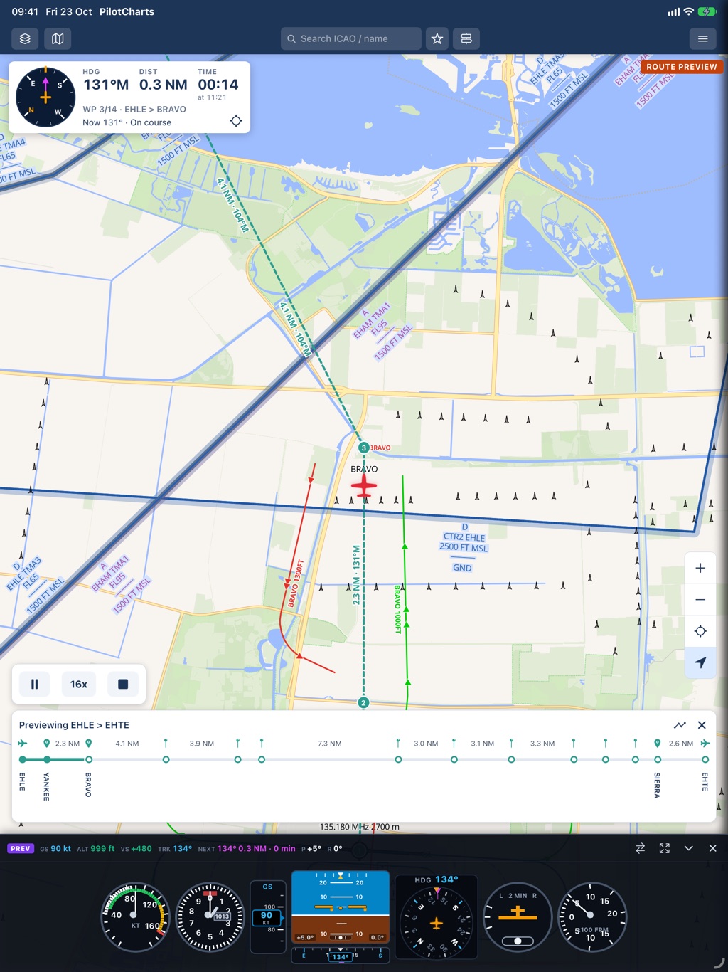
Engineered for the iPad — Landscape and Vertical
Whether mounted to your yoke, clamped to a kneeboard, or docked in the panel, PilotCharts adapts seamlessly to iPad in both orientations.
Side-by-Side Pinned Panels & Wide Instruments
In landscape orientation, PilotCharts delivers a desktop-class cockpit workstation. Pin aerodrome details, runway layouts, or route logs side-by-side with your chart without ever covering your moving GPS position. Flight instruments expand across the lower display with generous room for hybrid clusters.
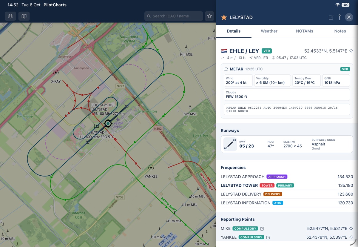
- Pinned side-by-side panels: Airport info, Route logs, and Planes stay open alongside the moving map
- Broad lateral chart awareness: enhanced peripheral vision through dense TMAs and CTR corridors
- Wide flight instruments: expandable Hybrid cluster or Glass PFD stretches comfortably across the bottom
- Ideal for yoke mounts, RAM arm brackets, and instrument panel docks
Maximum Forward Track, Six-Pack & Airspace NOTAMs
In portrait orientation, PilotCharts maximizes forward look-ahead distance along your flight path. Monitor miles of terrain, airspace corridors with dynamic active and deactivated NOTAM highlights, and approaching waypoints with round analog steam gauges or modern PFD instruments across the bottom.
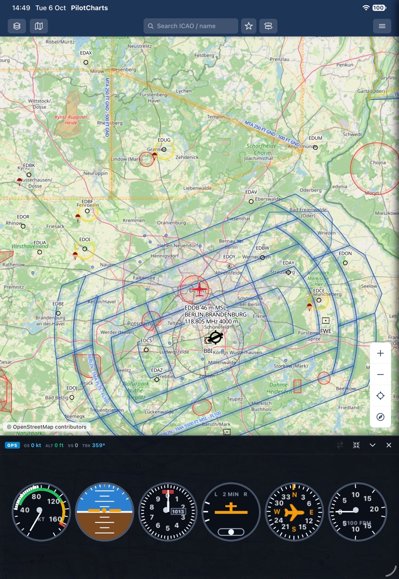
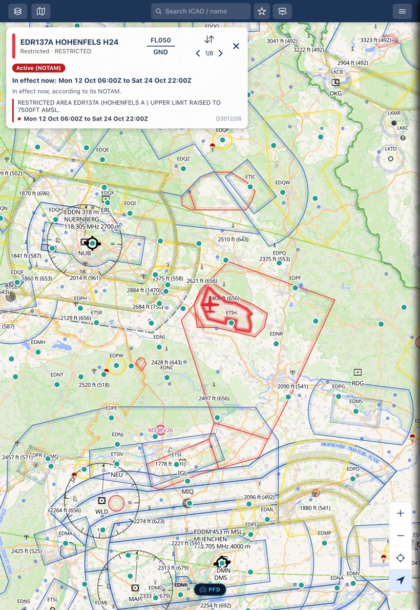
- Towering forward look-ahead: reveals approaching waypoints and airspace shelves far in advance
- Classic "Basic T" Six-Pack: full round analog steam gauges (ASI, attitude, altimeter, TC, DG, VSI)
- Dynamic airspace NOTAMs: highlights active restricted areas and TFR polygons along your flight corridor
- Clean kneeboard ergonomics: fits standard pilot thigh kneeboards with zero control stick interference
Built for real flying and cockpit workflows
Explore every major capability built into PilotCharts — from aerodrome intelligence and planes tracking to route elevation profiles and primary flight instruments.
50,000+ airfields, official AIP charts & live weather
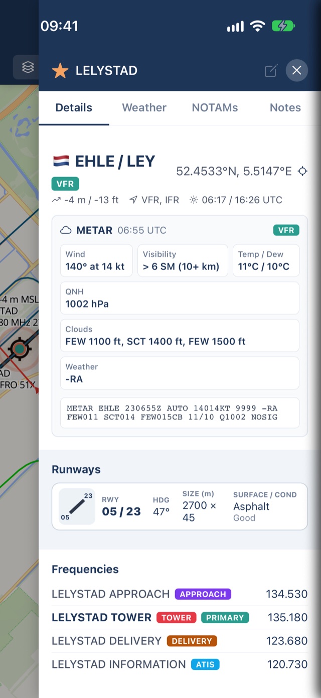
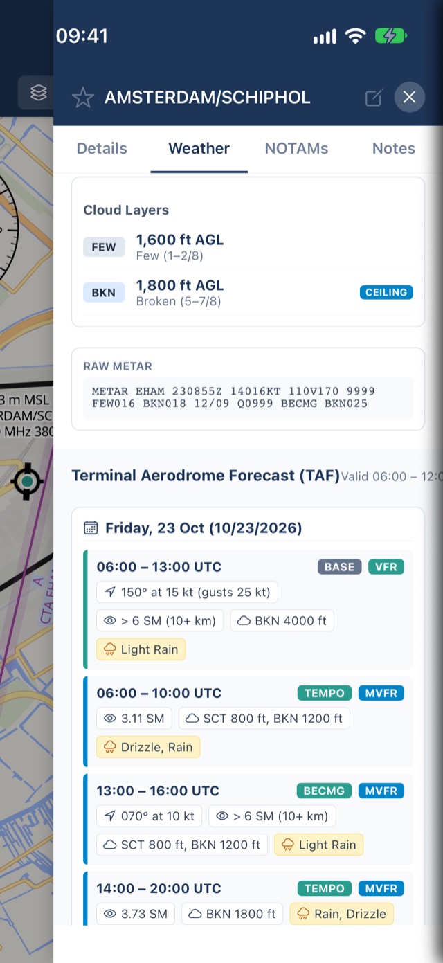
Access instant operational intelligence for international hubs, regional airports, backcountry grass strips, glider fields, and ultralight sites worldwide. Inspect runways with surface condition and headings, operational radio frequencies with purpose chips, decoded METAR & multi-day TAF, PPR contact details, and jump straight to official national AIP chart PDFs in one tap.
- 50,000+ airports, grass strips, glider sites, and heliports with instant search
- Detailed runway specs: true & magnetic headings, dimensions, surface type, and lighting
- Tower, Approach, Delivery, Ground, ATIS, and Info frequencies with active chips
- Official AIP chart PDF links for 50+ countries (FAA d-TPP, NAV CANADA, skeyes, Avinor, LFV, and more)
- Decoded METAR & TAF with plain-English summaries and flight category badges (VFR, MVFR, IFR, LIFR)
- Local pilot notes with proximity distance alerts and custom document attachments (PDFs & photos)
Track your aircraft with real photos, live telemetry & ADS-B
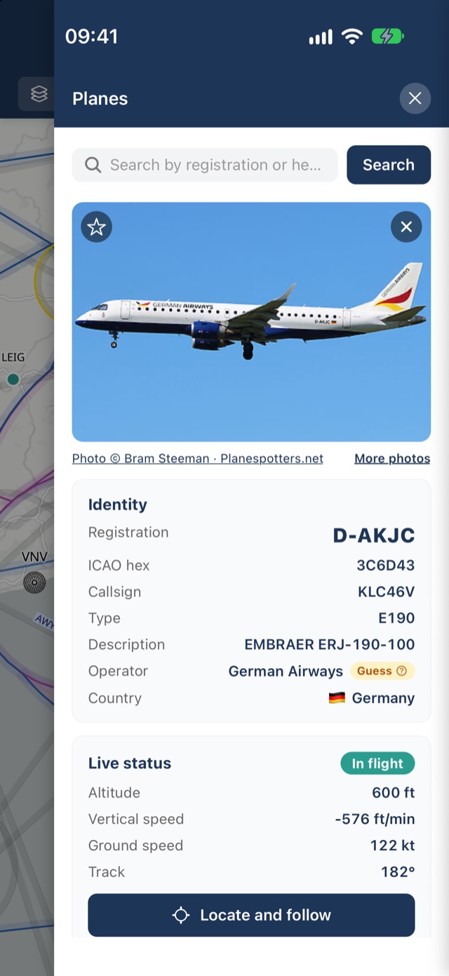
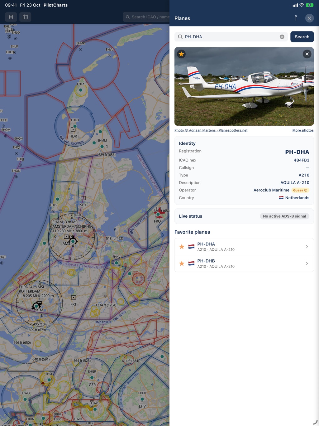
PilotCharts features a dedicated Planes panel for pilots and plane-spotters. Keep a curated list of favorite aircraft in your personal hangar, or tap any live ADS-B target on the chart to inspect tail number, type, smart operator identification, high-definition aircraft photos from Planespotters.net, and real-time telemetry.
- Personal fleet management: star and bookmark your favorite registrations and tracked aircraft
- Tap any ADS-B target on the map to open its complete aircraft card
- Real aircraft photography automatically fetched from Planespotters.net
- Identity verification: registration, ICAO 24-bit transponder hex, aircraft type, and operator guess
- Live telemetry status: pressure & GPS altitude, ground speed, track, vertical speed, squawk, bearing, and distance
- "Locate and follow" camera mode: smoothly follow any aircraft as it moves across the moving map
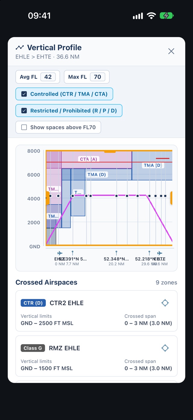
Multi-waypoint routes with 2D terrain elevation cross-sections
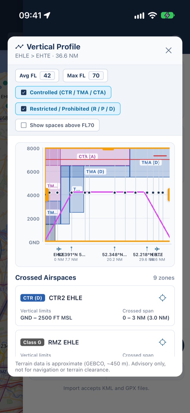
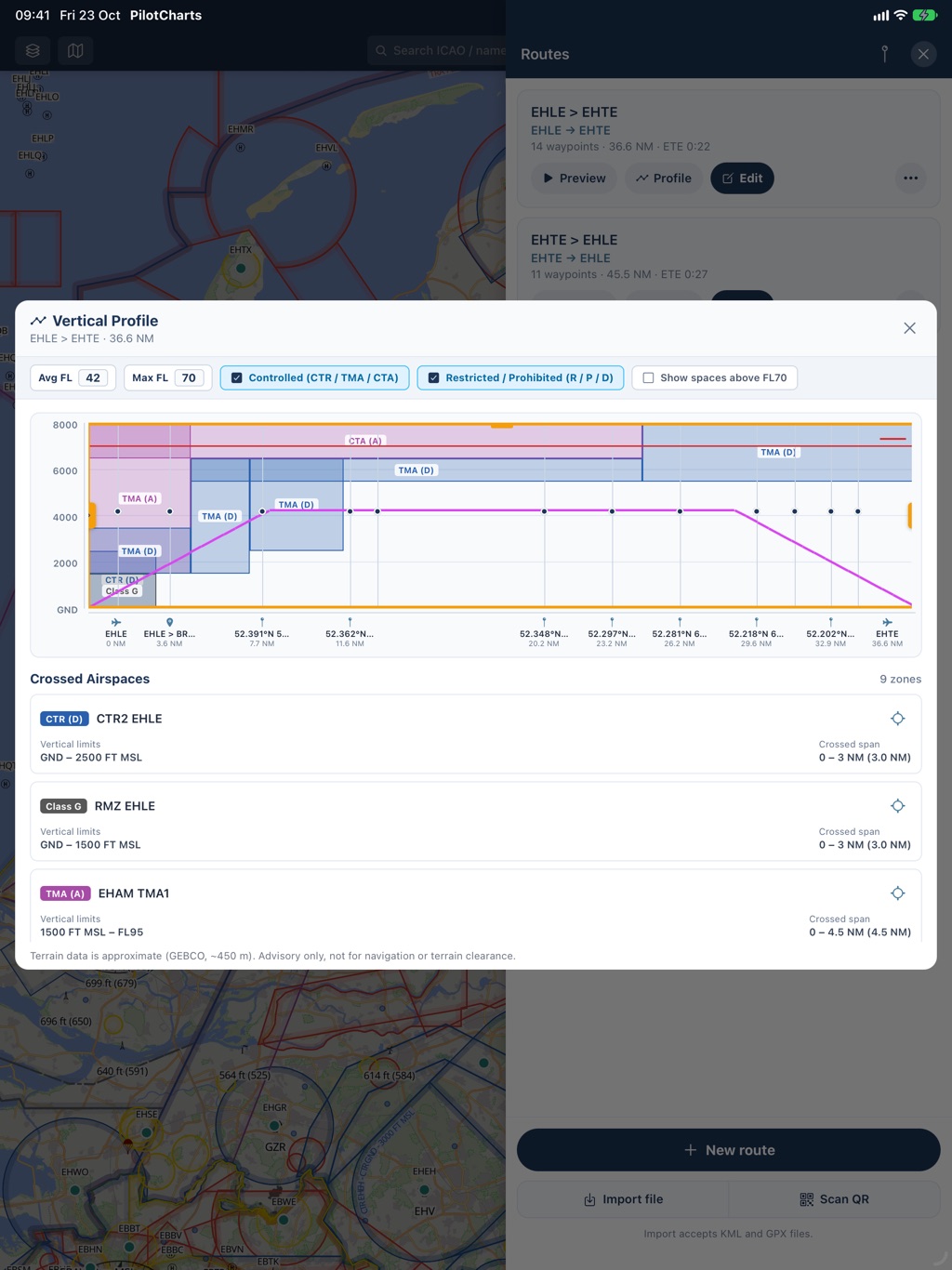
Plan VFR cross-country flights with full vertical situational awareness. Build multi-leg routes using airports, visual reporting points, VOR/NDB navaids, and custom user GPS coordinates. PilotCharts computes a high-resolution 2D terrain profile along your flight corridor using GEBCO 2024 data, plots ground elevation against your cruise altitude, and displays every crossed airspace shelf.
- High-resolution 2D terrain cross-section with ground profile and highest obstacle points
- Crossed airspaces mapped directly over your route with floor/ceiling limits and class colors
- Draggable range slider to inspect terrain elevation, clearance, and airspaces at any point
- Navigation calculations: magnetic & true headings, leg distances (NM), ground speeds, and ETE/ETA
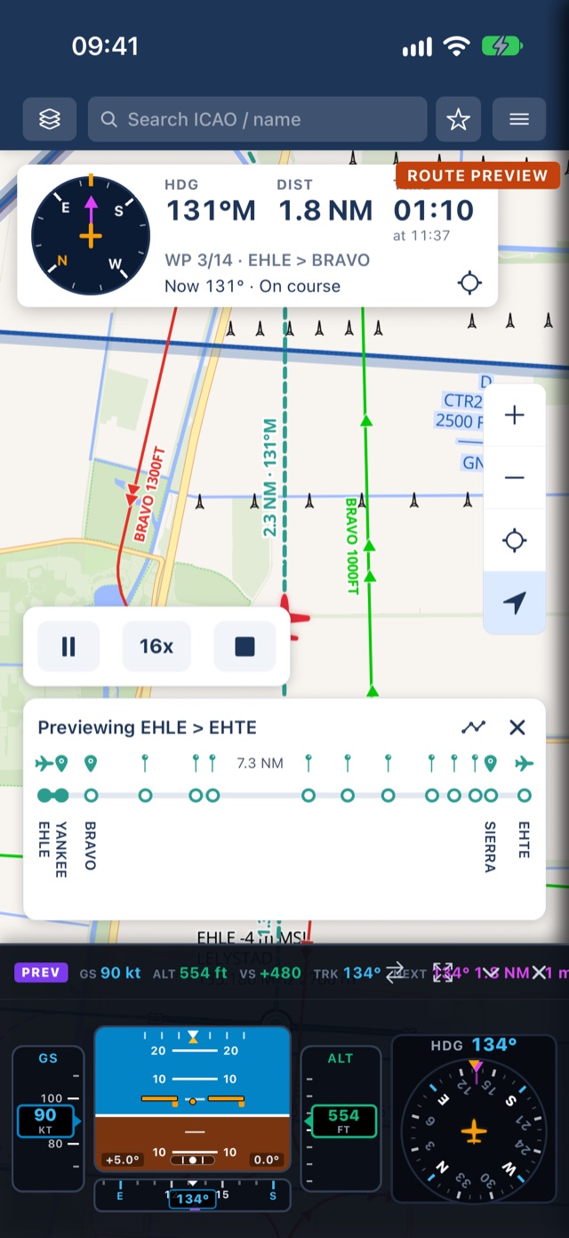
- Route playback simulation mode to preview your planned flight ahead of time
- Professional Pilot Briefing PDF export: route overview map screenshot, waypoint navlog table, notes, and QR code to share routes
Glass PFD, classic analog steam gauges, or hybrid cluster
Transform your device into a primary flight display. Switch effortlessly between a modern Glass PFD (smooth airspeed and altitude tapes, artificial horizon with pitch/roll ladder, vertical speed indicator, and 360° rotating compass rose), classic "Basic T" Six-Pack round analog steam gauges with colored airspeed arcs, or a wide Hybrid cluster. Connect to X-Plane or MSFS via local UDP to practice in your home simulator.
- Modern Glass PFD: moving airspeed & altitude tapes, artificial horizon, VSI scale, and directional tape
- 360° rotating Compass Rose (HSI) with GA plane symbol, lubber line, and active route waypoint bug (magenta pointer + ETA/distance badge)
- Classic Six-Pack analog steam gauges: standard Basic-T arrangement (ASI, attitude, altimeter, turn coordinator, DG, VSI)
- Wide Hybrid layout combining digital tapes with round analog gauges
- Flight simulator UDP integration: stream telemetry from X-Plane and Microsoft Flight Simulator (ForeFlight protocol)
- Collapsible & resizable: toggle between full cluster, compact telemetry strip, or dismiss to a minimal floating badge
Customize every airspace color, aircraft symbol & map theme
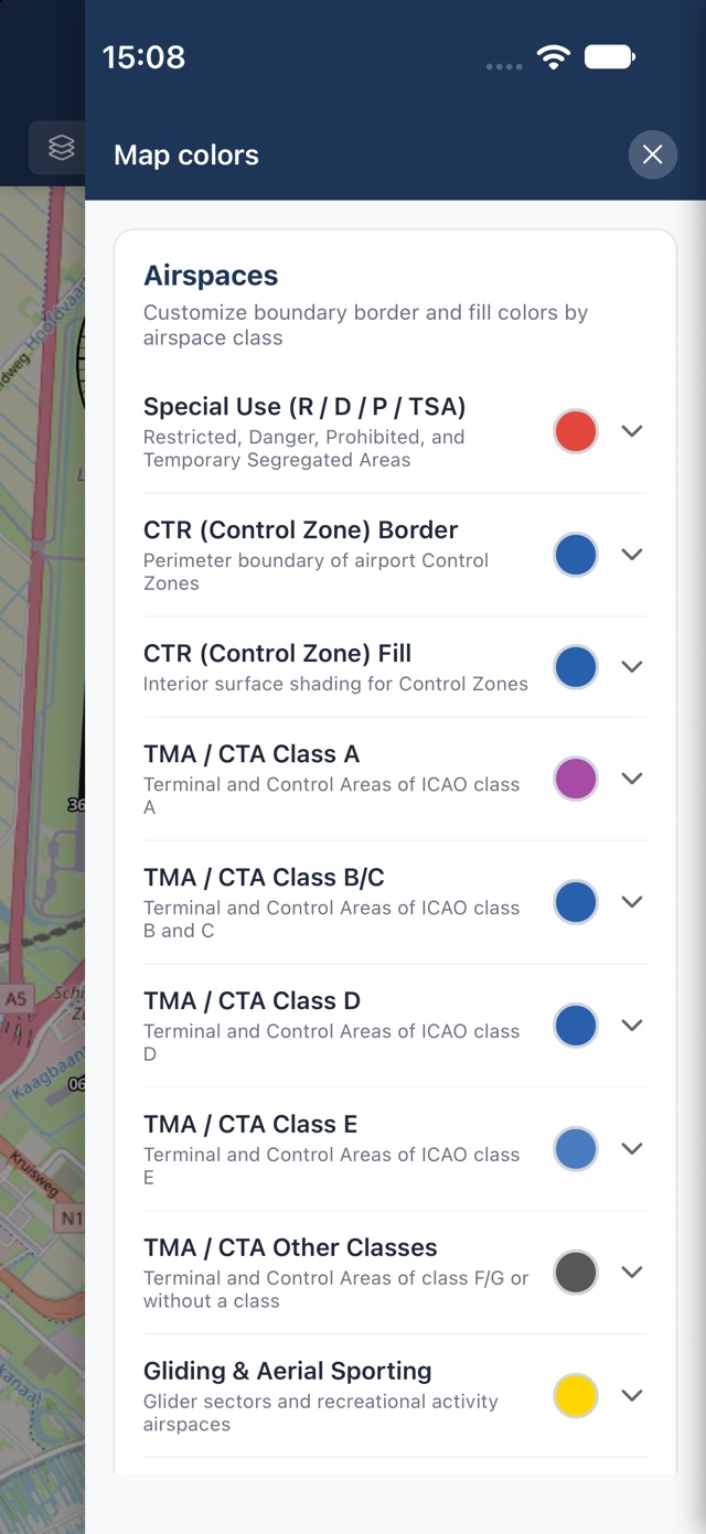
Every pilot has distinct preferences in the cockpit. PilotCharts offers unprecedented map personalization: recolor every airspace class independently, tune border thickness multipliers, zone fill opacity, border stripes/hatching, and inner boundary shading. Choose your aircraft marker shape and color, pick high-performance base map vector or satellite themes, and position on-screen controls in any corner.
- Recolor every airspace class (CTR, TMA, Gliding, Special Use, Classes A through G)
- Airspace styling: adjust border thickness, zone fill opacity, border stripes, and inner boundary shading
- Aircraft marker customization: choose icon shape (Light GA, Cessna 172 high-wing, Jet, Airliner) and custom color
- Base map themes: OpenFreeMap vector styles (Liberty, Bright, Positron, Dark), Esri World Imagery satellite, and OSM
- Configurable floating controls: place zoom, GPS centering, stopwatch, and PFD reopen buttons in any screen corner
- North-Up vs Heading-Up chart rotation with customizable follow zoom and label stacking detail thresholds
- Multilingual support: localized into 9 languages (English, Spanish, Catalan, Dutch, German, French, Italian, Romanian, and Greek) with automatic system detection
Deconstruct complex airspace shelves with a single tap
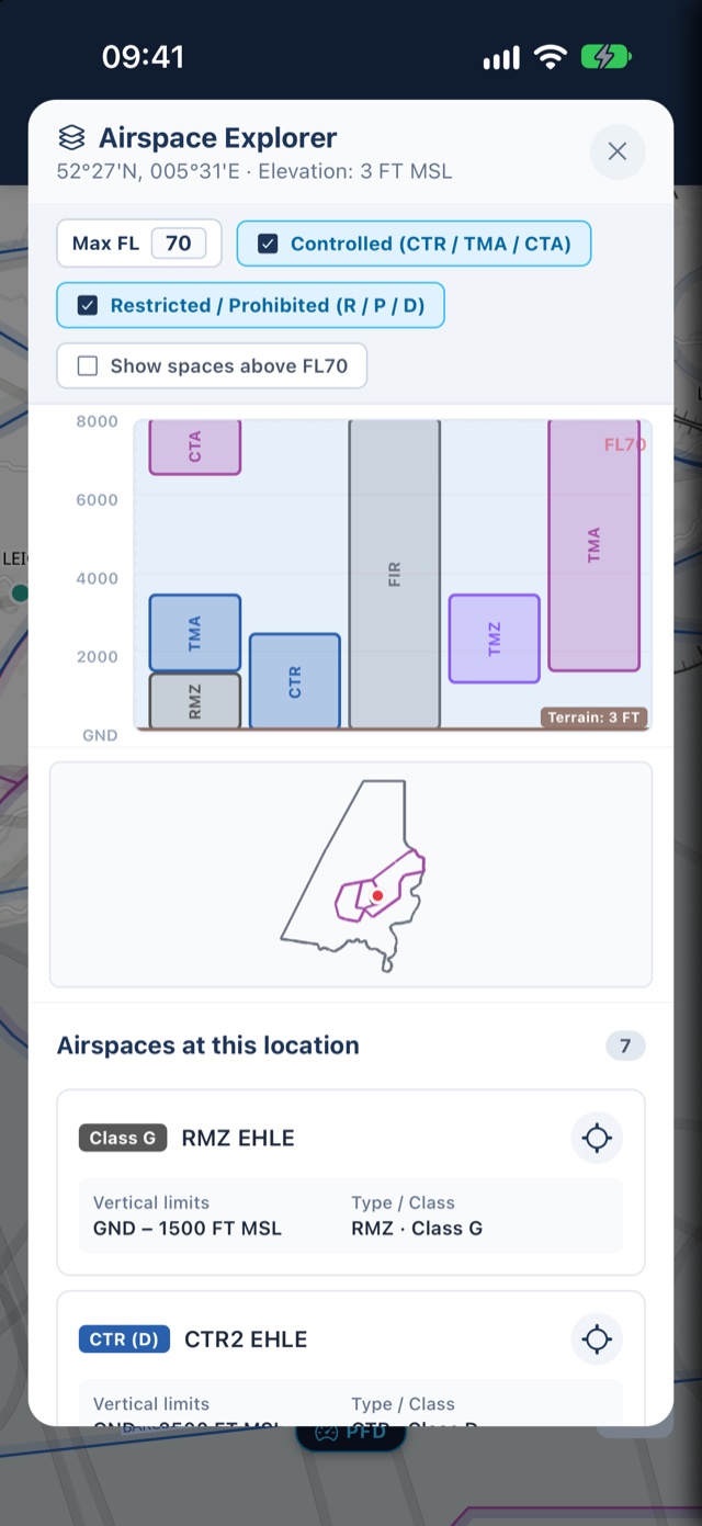
Controlled airspace often stacks in complex steps and shelves that are hard to interpret on a flat map. Long-press anywhere on the chart or tap an airspace boundary to open the Airspace Explorer. PilotCharts cuts a vertical slice from ground level up to FL660, displaying all intersecting airspace layers in clear side-by-side vertical columns with smart filtering and an interactive cruise ceiling reference.
- Smart route-style filters: Filter by controlled airspace, restricted / danger zones, or hide spaces above your cruise level
- Interactive Max FL ceiling line: Set your target altitude (e.g. FL70) to see a dashed cruise ceiling across all vertical slices
- Side-by-side vertical column lanes: Clear floor and ceiling limits with explicit MSL, AGL, and Flight Level (FL) readouts
- Frequencies & callsigns: Instant access to active tower, radar, and information frequencies right on each column
- Live footprint outlines: Tap any airspace column to highlight its precise perimeter on the moving map
Dynamic active & inactive airspace status, TFRs & schedules
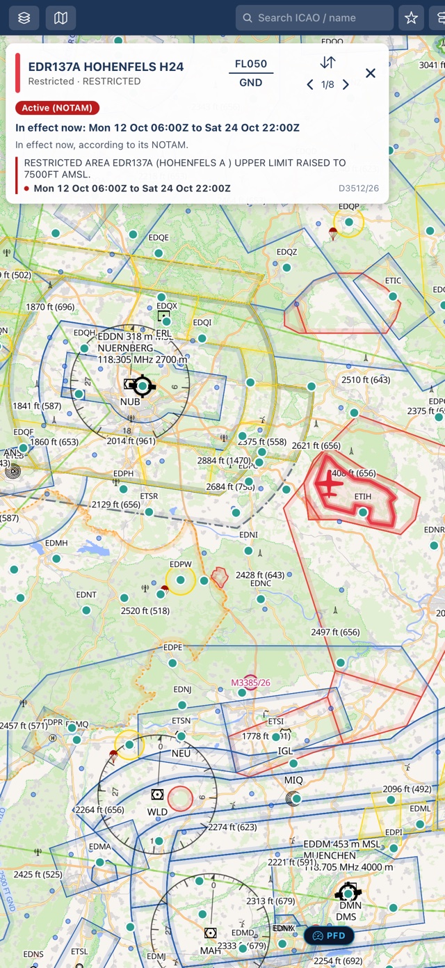
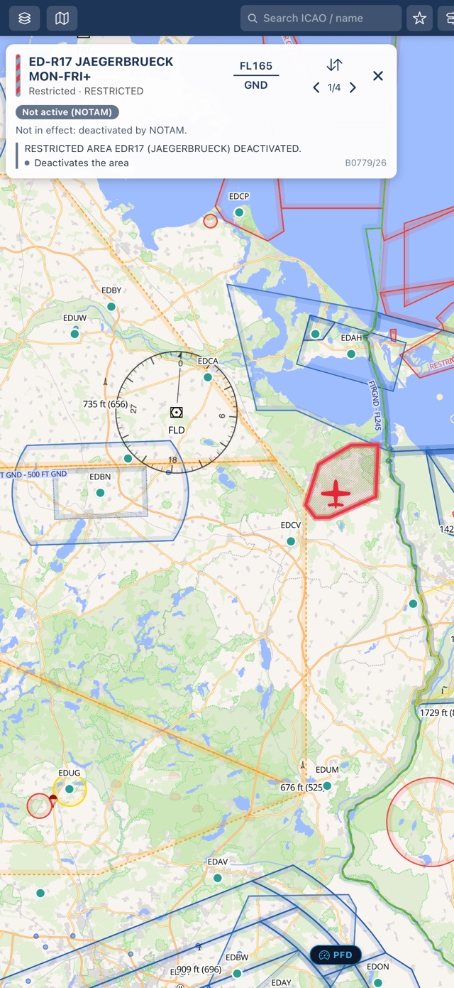
Never guess whether a military restricted area, danger zone, or CTR is actually hot. PilotCharts connects airspace geometries directly to official NOTAM feeds, calculating whether each zone is currently active, deactivated, or scheduled for activation. Active restricted areas glow with bold boundary highlights and raised ceiling alerts, while cold airspaces switch to transparent diagonal grey hatching and dashed borders. Temporary flight restrictions (TFRs) and drone activity corridors are drawn as dedicated NOTAM polygons directly over your moving chart with full UTC validity windows.
- Dynamic visual states: Instantly distinguish Active (solid border & glowing boundary), Inactive (diagonal grey hatching, dashed outline), and Unknown airspaces
- Temporary Flight Restrictions (TFRs): NOTAM-defined drop zones, air shows, and drone corridors rendered as dedicated polygon areas on the chart
- UTC schedule windows & recurring rules: Tap any airspace card to view active UTC timeframes, effective dates, ceiling changes, and full NOTAM text
- Hide inactive military airspace: One toggle in Settings hides cold danger and restricted areas completely, decluttering congested corridors
- Active status badges: Green “Active (NOTAM)”, amber “Not active (NOTAM)”, and schedule countdowns displayed directly on airspace cards
- 24-hour offline persistence: Active NOTAM polygons and status rules persist to disk so your chart awareness stays sharp without cellular signal
Decoded METAR, TAF, live radar, and airport pre-flight NOTAMs
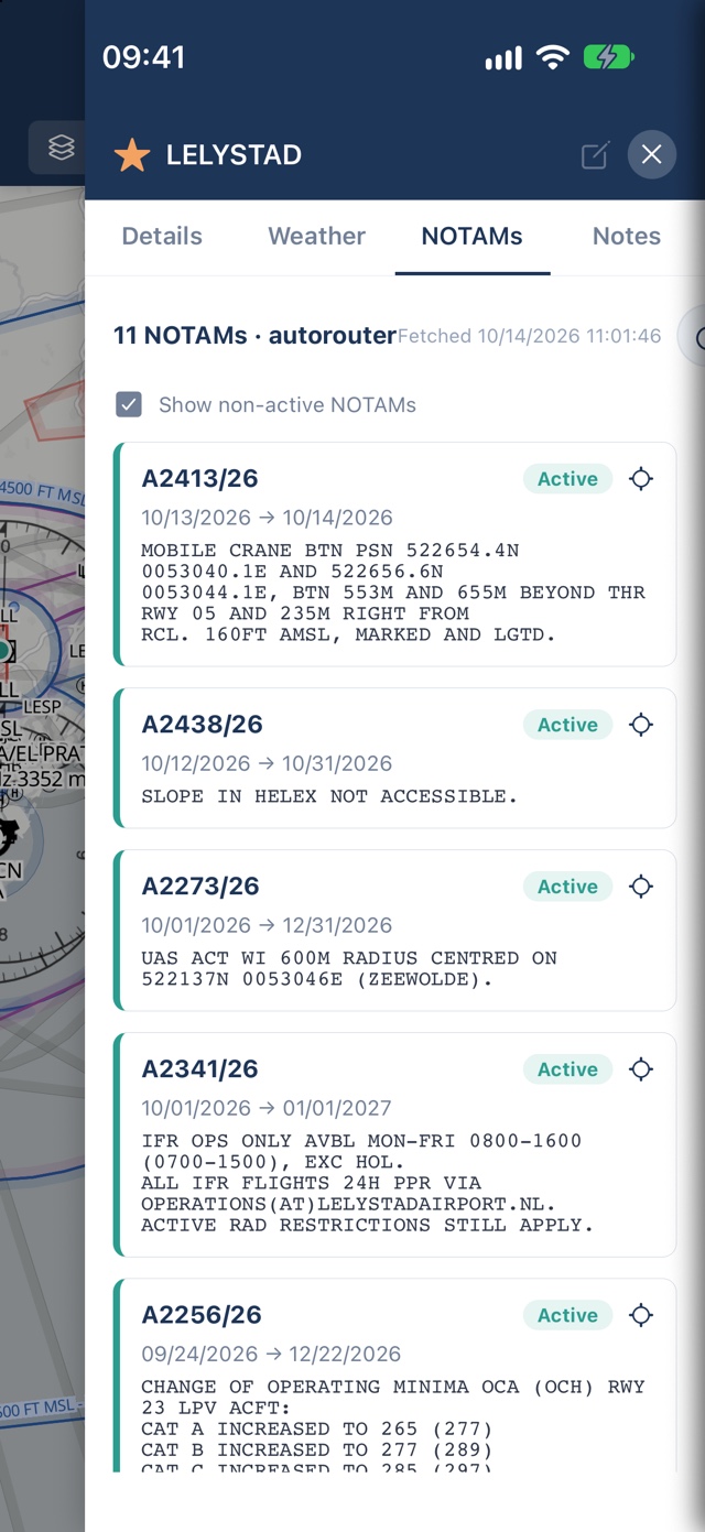
Get the complete pre-flight and en-route operational picture. Inspect live METAR and multi-day TAF with instant flight-category badges (VFR, MVFR, IFR, LIFR) and plain-English decoding. Check real-time rain radar, wind barbs, and cloud cover chart overlays. Review aerodrome NOTAMs fetched via FAA NMS and Autorouter with active validity windows, runway closure tags, and tap-to-spotlight coordinates on your chart.
- Decoded and raw METAR / TAF straight from NOAA Aviation Weather Center and DWD
- Airport NOTAMs tab from FAA NMS and Autorouter with active, upcoming, and expired status badges
- Tap any NOTAM coordinate to spotlight the affected location on the moving map
- Rain radar, wind barbs, cloud cover, and surface pressure chart overlays
- Comprehensive Route Briefing PDF export combining route navlog, waypoint notes, airport weather, and NOTAMs
Download by country or continent — fly anywhere offline
PilotCharts is built for the reality of general aviation: you can't rely on cellular signal at 5,000 feet. Base map vector and satellite tiles cache automatically as you browse. Download complete country data packs covering airports, reporting points, VFR routes, navaids, airspaces, obstacles, and high-resolution GEBCO 2024 terrain elevation packs pre-generated by the PilotCharts backend.
- Continent & worldwide downloads: One-tap batch downloads for entire continents (Europe, North America, etc.) with verified download sizes
- Complete offline data packs: Airports, grass strips, reporting points, VFR routes, navaids, airspaces, and obstacles
- GEBCO 2024 terrain elevation: Pre-generated offline elevation grids for accurate terrain profile rendering without an internet connection
- VAC/ADC chart link indicators: Country badges highlight where official visual approach and aerodrome charts are available
- Automatic ambient map caching: Every vector or satellite tile viewed is saved to disk for offline access
Handwritten pilot notes, clearances & kneeboard sheets
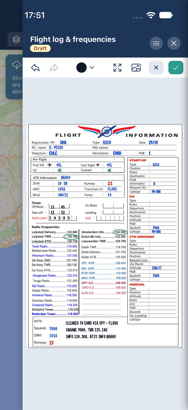
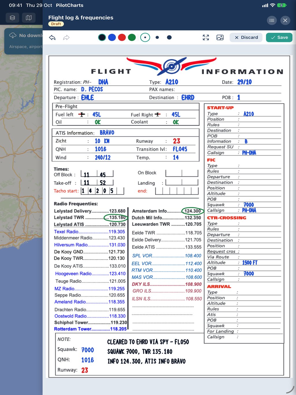
Capture ATC clearances, ATIS reports, frequencies, and taxi instructions in real time. Designed for high turbulence and quick cockpit scribbles with Apple Pencil, stylus, or your finger. Draw freely on blank sheets, ruled pages, or use custom document backgrounds like flight logs, kneeboard templates, and approach briefings with automatic multi-device synchronization.
- Apple Pencil & stylus support: Smooth, low-latency vector inking with customizable stroke widths and colors (blue, black, red, green, amber, white)
- Document backgrounds: Import and underlay kneeboard templates, flight logs, weather briefings, or approach plates from your Library
- Pattern sheets: Choose between plain paper, ruled lines, math grid, or dot grid patterns
- Autosave & revisions: Never lose a note — drafts save automatically, with full undo and redo history
- Cross-device cloud sync: Notes and kneeboard scribbles stay synced across all your iPads and iPhones
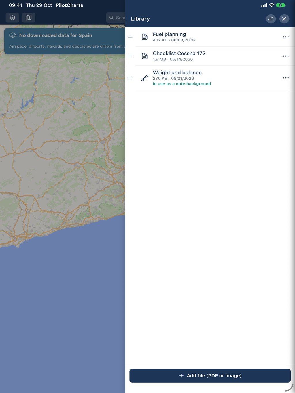
All your checklists, POH manuals & charts in one place
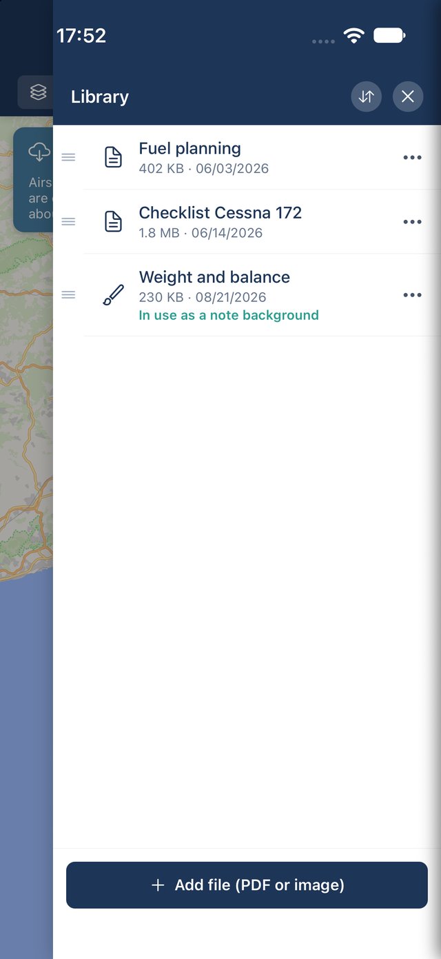
Ditch bulky paper binders in the cockpit. The PilotCharts Library lets you store, organize, and view all your personal flight documents, aircraft operating handbooks (POH), emergency checklists, performance and circuit speed sheets, weight & balance forms, and custom VFR/IFR charts. Every document is securely stored locally on your device for immediate offline access in the air.
- Multi-format support: Store PDFs and high-resolution images with instant thumbnail previews and file sizes
- Built-in document viewer: View multi-page PDFs and images with pinch-to-zoom, smooth scrolling, and full-screen reading
- 1-tap notepad integration: Turn any library document or kneeboard image into a writable background in Cockpit Notepad with a single tap
- Custom sorting & search: Organize files by date, size, or custom title for rapid access when you need it most
- 100% offline access: All documents are kept directly on your device, ready to open at any altitude without a network connection
Free to fly. Pro to do more.
The moving map, over 50,000 airfields, search, and airport details stay free forever — no trial clock, no feature cliff.
- Live GPS moving map with VFR aeronautical chart overlay
- Automatic offline map caching
- 50,000+ airports, grass strips & glider fields worldwide
- Airport details from openAIP — runways, frequencies, PPR, hours
- Official AIP chart PDF links for 50+ countries
- Closest-airports lookup
- Per-country downloads for airports, navaids, airspace & obstacles
- North up / Heading up chart orientation
- Floating flight stopwatch timer
- Multilingual support: localized into 9 languages
- Favorite airports & planes, Planes panel with locate & follow
- Free account: sync favorites, airport notes, settings & layers across your devices, and download up to 4 countries
- Everything in Free
- Cross-device sync of routes, Library files, Notepad notes & map styling
- Live Air Traffic with category silhouettes & Planespotters photos
- Airspace Explorer vertical column stack & active frequencies
- Dynamic Airspace NOTAMs on the map with active/inactive visual status & TFRs
- Route Planning with 2D terrain elevation cross-sections & airspace crossings
- Worldwide NOTAMs from FAA & Autorouter with active status badges & chart spotlight
- Glass Cockpit PFD (speed & altitude tapes, artificial horizon, VSI, compass rose)
- Classic Six-Pack analog steam gauges & Hybrid cluster styles
- Route briefing PDF export with map overview, weather & NOTAMs
- Desktop flight simulator UDP streaming (X-Plane & MSFS)
- Decoded METAR & TAF aviation weather with flight categories
- Rain radar, wind, clouds & pressure weather overlays
- Full map color & styling personalization, custom pilot notes & PDF attachments
- Pre-generated GEBCO 2024 global elevation packs
Compare plan features
A side-by-side breakdown of features included in the Free account and unlocked with Premium (Pro).
| Feature | Free €0 forever No account required | Free in beta Premium / Pro €0 in beta With free account |
|---|---|---|
| Moving Map & Navigation | ||
| Live GPS Moving Map Real-time aircraft position, track vector, speed and heading overlay | ||
| Aeronautical VFR Vector Overlay Controlled airspaces, special use zones, CTRs, TMAs, VFR routes and reporting points from openAIP | ||
| Base Map Themes OpenFreeMap (Liberty, Bright, Positron, Dark), Satellite raster, OpenStreetMap & Borders | ||
| Automatic Offline Tile Caching Ambient vector and satellite tiles automatically cache to disk as you browse | ||
| North Up & Heading Up Orientations Chart smoothly rotates with aircraft heading or fixes to true north | ||
| Flight Stopwatch Timer Floating draggable stopwatch with lap times and quick reset | ||
| Flight Simulator Connectivity Direct UDP telemetry from X-Plane and Microsoft Flight Simulator (MSFS) over Wi-Fi | ||
| Airports & Aerodrome Data | ||
| 50,000+ Worldwide Airfields International airports, regional fields, ultralight strips and glider fields from openAIP | ||
| Aerodrome Specifications Runway dimensions, surface, lighting, pattern, radio frequencies, PPR rules and hours | ||
| Official AIP Chart PDF Links Direct links to official national visual approach (VAC) and aerodrome (ADC) charts in 50+ countries | ||
| Airport Search & Closest Aerodromes Instant search by ICAO, IATA or name plus GPS proximity list with bearings & distance | ||
| Custom Pilot Notes Personal notes for any aerodrome or waypoint | ||
| Handwritten Notepad Sketch kneeboard notes with a pen or finger on ruled, grid or image backgrounds | ||
| Per-Airport Documents & Files Attach local PDF charts and approach plates directly to any aerodrome | ||
| Favorite Airports Starred aerodromes dropdown for one-tap navigation, synced across your devices with a free account | ||
| Airspace Intelligence & NOTAMs | ||
| Dynamic Airspace NOTAMs on Map Live active (solid highlight) and deactivated (grey diagonal hatching) status for controlled zones | ||
| Temporary Flight Restrictions (TFRs) Dynamic NOTAM hazard polygons drawn directly on the aeronautical chart | ||
| Airport NOTAM Briefings Decoded notices from FAA NMS & Autorouter with validity dates, status badges & chart spotlight | ||
| Airspace Explorer Long-press chart inspection for complete vertical airspace column stacks & active frequencies | ||
| Airspace Altitude Filter Altitude ceiling slider to declutter or dim inactive and high-altitude airspaces | ||
| Aviation Weather | ||
| Decoded METAR Weather Current observation, flight category (VFR, MVFR, IFR, LIFR), wind, visibility & clouds | ||
| TAF Terminal Aerodrome Forecasts Decoded terminal forecasts with timed change groups (BECMG, TEMPO, PROB) | ||
| Rain Radar Live Weather Layer Live high-resolution precipitation radar overlay powered by RainViewer | ||
| Wind, Clouds, Temperature & Pressure Overlays Animated wind particle streams, cloud deck covers and barometric pressure isobars | ||
| Flight Planning & Route Profiles | ||
| Interactive Route Planning Multi-leg VFR route builder with rubber-band waypoint dragging on the moving chart | ||
| 2D Terrain Elevation Profile Ground cross-section along the flight corridor computed from GEBCO 2024 global elevation | ||
| Airspace Corridor Crossings Vertical slice of controlled airspaces along the flight route with top obstacle flags | ||
| In-Flight Next Leg Guidance Heading-up waypoint bug card with distance, bearing, ETE and turn advisory | ||
| Route Briefing PDF Export Comprehensive printable pre-flight pack with route chart, navlog, weather & NOTAMs | ||
| Route Import & Export Interchange routes seamlessly via GPX, KML and cross-device QR code scanning | ||
| Traffic & Fleet | ||
| Aircraft Registry & Photos Look up aircraft by tail number or ICAO hex with high-resolution Planespotters.net photos | ||
| Air Traffic Map Layer Real-time aircraft targets with category silhouettes, altitude, ground speed and squawk | ||
| Locate & Follow Aircraft Keep map camera centered on any airborne flight target in real time | ||
| Personal Fleet & Favorite Planes Quick-access aircraft list with saved registrations and status indicators | ||
| Flight Instruments (Cockpit) | ||
| Classic Six-Pack Analog Steam Gauges Basic-T cluster: Airspeed with color arcs, Attitude, Altimeter, Turn Coordinator, Directional Gyro, VSI | ||
| Modern Glass Cockpit Primary Flight Display (PFD) Digital moving speed & altitude tapes, artificial horizon, digital VSI and directional tape | ||
| Hybrid Cockpit Cluster Expanded PFD with circular 360° rotating Compass Rose dial and active waypoint bug | ||
| Customizable Instrument Cluster Toggle individual instruments on or off according to pilot preference | ||
| Terrain & Elevation | ||
| Airport & Waypoint Elevation Readouts Precise field elevation in feet MSL across all aerodrome cards | ||
| Terrain Elevation Heatmap Layer Offline hypsometric tint raster overlay derived from the GEBCO 2024 global grid | ||
| Offline Packs & Cloud Sync | ||
| Offline Country Data Packs Download airports, navaids, airspaces, obstacles and elevation by country | 2 countries · 4 with a free account | Unlimited worldwide |
| Cross-Device Cloud Sync Free account: favorite airports and planes, airport notes, settings and layer toggles. Premium adds flight routes, uploaded files, Notepad notes and map styling | With a free account favorites, airport notes, settings & layers |
Everything plus routes, files, Notepad & map styling |
| Cloud Document Library Central document repository for approach plates, checklists and kneeboard note backgrounds | ||
| Chart Personalization | ||
| Airspace Label Detail Zoom Threshold Adjust the zoom level at which stacked airspace information tags expand | ||
| Custom Map Colors & Styling Tailor colors for CTR, TMA/CTA by class, border width, zone fill opacity and stripes | ||
| Multilingual Support Full interface localization in 9 languages: English, Spanish, Catalan, Dutch, German, French, Italian, Romanian & Greek | ||
| Ready to get started? Fly with full offline maps or unlock all Pro features during beta. | Get Free | Get Pro in Beta |
Questions pilots ask
Is PilotCharts free?
What is the Planes and fleet tracking feature?
How does PilotCharts adapt to iPad in landscape and vertical?
What are the Airspace Explorer and Route Elevation Profile?
How do official national AIP chart links work?
How do NOTAMs work in PilotCharts?
On the moving chart: Controlled, restricted, and danger airspaces dynamically connect to official NOTAM feeds. The chart visually reflects whether an airspace is actively hot (solid outline and bold boundary highlight) or deactivated/cold (dimmed diagonal grey hatching and dashed border). Temporary flight restrictions (TFRs) and drone activity corridors are drawn as dedicated NOTAM polygons. Tap any airspace on the chart to inspect its active UTC schedule windows, effective dates, and full official text. Pilots can also enable the “Hide inactive airspace” setting to completely declutter cold military zones from the chart.
For airports: Each aerodrome panel includes a dedicated NOTAMs tab powered by FAA NMS and Autorouter gateways. Notices are decoded with clear validity date spans, categorized into active, upcoming, and expired badges, and feature one-tap coordinate geolocations that spotlight the exact affected taxiway, runway, or obstacle on the chart.
All NOTAM data is cached locally for 24 hours so you retain full operational awareness even when flying completely offline.
Can I connect PilotCharts to X-Plane or Microsoft Flight Simulator?
Can I use this for navigation?
Does it work without an internet connection?
Where does the data come from?
Which platforms does it support?
What languages does PilotCharts support?
When does it launch?